Everything is bigger in Texas, including the heat. But the recent heat wave there was big even by Texas standards, rewriting local weather records.
The anchor of the heat was in southwest Texas, which is already hot to begin with. In Del Rio, on the east side of the Rio Grande, an all-time high of 113 degrees was set on June 20. The next day, it was even hotter, reaching 115 degrees.

David J. Phillip, Associated Press
Sweat rolls off the lip of Robert Harris as he digs fence post holes Tuesday in Houston. Scorching temperatures taxed the Texas power grid and brought record highs to the state.
San Angelo reached 114 degrees on back-to-back days on the 20th and 21st. Laredo tied its all-time record of 115 degrees on the 19th.
Richard Berler, a veteran broadcast meteorologist for KGNS in Laredo since 1980, has kept meticulous weather records and was amazed at the consistency of the heat.
“This was the hottest 16-day period in the Laredo record (June 13-28), with records going back to 1895. Sporadic records which go back to 1849 at old Fort McIntosh show no heat episode that equals what we have just experienced.”
And there was not much cooling at night, making it even more difficult for the body to recover from the intense heat of the day.
“We just recorded 14 consecutive midnights at or above 90 degrees,” Berler said, adding that some years have none. “We had 102 degrees at 10 p.m. on 2 nights. Tragically, eight people in our county lost their lives due to heat illness last week, nine across the river in Nuevo Laredo.”
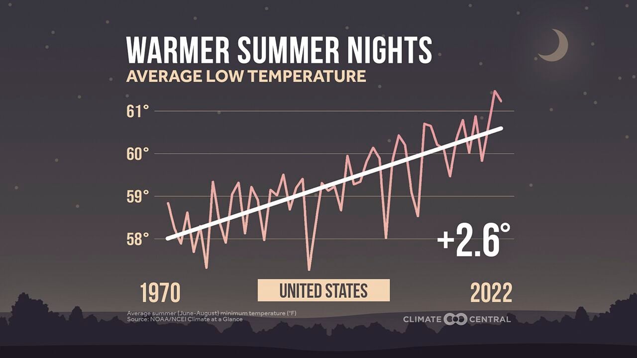
CLIMATE CENTRAL
Nationally averaged summer low temperature since 1970 have been climbing.
The intensity of heat is one of the most direct connections to the warming climate. As the planet has warmed over the past century, the hottest weather is getting hotter, and the coldest weather is not as cold.

Raquel Natalicchio, Associated Press
Ed Newby, owner of All Star A/C and Heating, fields calls during a heat wave Monday in Houston.
Carbon dioxide in the atmosphere, a greenhouse gas emitted from the burning of coal, oil and natural gas, has increased more than 30 percent since 1958, and it is the primary reason the climate is warming. It may not cause the heat on any one day, but it drives the weather patterns that lead to the extreme heat.
Like stacking a deck of cards or loading a pair of dice, it makes extreme heat on any given day more likely than a century ago. More troubling, there is growing evidence that such extremes are now lasting longer.
Weather patterns in the middle latitudes — that area between the Arctic and the tropics — are largely governed by how the winds move several miles up in the atmosphere. The strongest part of those winds are known as the jet stream.
In general, those winds travel from west to east across North America, moving weather systems along at a reasonable pace. However, they rarely travel in a straight line. When swings in those winds to the north or to the south become large, weather patterns become stagnant, whether they are wet patterns, cold spells or, in the case of Texas recently, heat waves.
The speed and direction of the jet stream winds are largely governed by the temperature difference between the poles and the tropics. A bigger difference in that temperature leads to a faster jet stream, but also one that tends to move in a more direct west to east fashion. And this is where the warming climate may be playing a secondary role.
Over the last half-century, the Arctic has warmed about three to four times more than the rest of the world, so the temperature difference from the poles to the tropics is decreasing, weakening those winds. And like water moving through a stream, as the wind slows down, it starts to meander — less likely to continue in a straight line.
The result, in work pioneered by Jennifer Francis at the Woodwell Climate Research Center in Massachusetts, is a jet stream flow that may tend to become much more wavy.

Eric Gay, Associated Press
Tubers float the Comal River on Thursday in New Braunfels, Texas, to try to beat the heat.
This leads to larger bulges both north and south, slowing down the progression of weather systems across the continent like cars in a traffic jam. Consequently, the weather over any one point becomes stagnant. During this time of the year in Texas, that means heat.
The pattern has broken down for now, so the worst of the heat has migrated into the mid-South, giving Texas a break. But July is climatologically the hottest month of the year nationally, and there are signs of another surge of intense heat across the Plains later in the month.
This year is on pace to be one of the 10 hottest on record globally, so expect heat waves like these to gradually become more common as the climate warms. How much more common will depend on how quickly we can reduce emissions of greenhouse gases — like carbon dioxide.
Sean Sublette is the chief meteorologist for the Richmond Times-Dispatch in Virginia.
-
Earth in hot water? Worries over sudden ocean warming spike
Alohaflaminggo // Shutterstock
Almost daily, more headlines about climate change—how it exacerbates natural disasters, impacts tourism, threatens species with extinction, or creates cultural shifts due to sea level rise or drought impacts on local economies—hit the news media.
The Intergovernmental Panel on Climate Change's latest report, released on March 20, 2023, both summarizes the previous five years' findings and offers a renewed warning on the degree to which greenhouse gas emissions must be curbed if there is any hope of meeting the Paris Agreement's goal of capping global warming close to 1.5 degrees Celsius (2.7 degrees Fahrenheit). According to the report, "emissions need to be reduced by at least 43% by 2030 compared to 2019 levels, and at least 60% by 2035" to meet that target. And right now, that's looking like a lofty goal: There is a more than 50% chance that the 1.5-degree threshold will be reached, if not exceeded, by 2040.
As more of a spotlight is shone on these pressing issues, so, too, appear myriad associated buzzwords—from fossil fuels and carbon to biofuels and ozone. And as the climate change conversation becomes increasingly ubiquitous and complicated, it's helpful to grasp some of its most significant terms, starting with the definition of "climate change" itself.
Stacker compiled 25 terms related to climate change, their meanings, and their significance in the context of today's warming climate. This gallery is not inclusive (thousands of terms relate to the climate change discussion) but is meant as a starting point to better understand what is arguably shaping up to be the most pressing issue of the near—and distant—future.
At its most fundamental, climate change refers to new weather patterns sustained over time—decades to thousands or even millions of years—because of fluctuations in Earth's climate system which includes its atmosphere, biosphere, cryosphere, hydrosphere, and lithosphere. The planet has undergone many significant (and natural) climate changes over the past 4.5 billion years, including ice ages and global melts.
About 12,000 years ago, the climate reached stable temperatures hospitable to humans. The resulting farming and settling that occurred led to a need for fuel to power newly invented machines; people found it in coal. But as the coal burned, it released the carbon it held. Then came the oil industry in 1859, when Edwin L. Drake drilled the first oil well. All that burning of fossil fuels for industry and transportation—and methane from livestock and the burning of natural gas—has sent much higher levels of emissions into the atmosphere than ever before, fueling a period of global warming that is happening faster than at any time in the past 2,000 years.
After thousands of years with average temperatures barely fluctuating by more than a degree Celsius, many experts agree that the world will likely experience three degrees of warming by the end of this century. That's because, for the first time, we're seeing what civilization's effect on Earth's climate system is and how it affects all of us.
You may also like: Notable events in the history of Earth Day
-
Earth in hot water? Worries over sudden ocean warming spike
Cherries // Shutterstock
Weather is the state of the atmosphere at any given time and place over a limited period—minute to minute, day to day, or week to week, for example. Weather can fluctuate wildly over the course of a month or year, and such fluctuations are becoming more frequent and more intense as global temperatures rise.
-
-
Earth in hot water? Worries over sudden ocean warming spike
Piyaset // Shutterstock
Climate refers to average weather patterns over long periods of time. Weather trends are indicative of larger climate patterns when the trends can be charted over at least a 30-year span.
Piyaset // Shutterstock
Climate refers to average weather patterns over long periods of time. Weather trends are indicative of larger climate patterns when the trends can be charted over at least a 30-year span.
-
Earth in hot water? Worries over sudden ocean warming spike
Robert Szymanski // Shutterstock
Ice sheets are continental glaciers exceeding 50,000 square kilometers (about 20,000 square miles). In one 24-hour period in August 2019, Greenland's ice sheet lost 11 billion tons of ice. While it's normal for the ice sheet to lose some ice every summer (and regain some in the winter), 2019's melt season came almost a full month early and was exacerbated by record-high temperatures.
-
-
Earth in hot water? Worries over sudden ocean warming spike
FloridaStock // Shutterstock
Global warming, an increase in average global surface temperature over an extended period, is one aspect of climate change (the two terms should not be used interchangeably). Today's global warming is attributed to high emissions, including CO2, methane, and chlorofluorocarbons.
-
Earth in hot water? Worries over sudden ocean warming spike
Ugis Riba // Shutterstock
The chemical compound carbon dioxide (one part carbon and two parts oxygen) is a gas produced by respiration and the burning of carbon and other organic compounds. Plants absorb CO2 during photosynthesis, making the gas a fundamental component of all life on Earth. CO2 traps heat radiating off Earth's surface in the atmosphere, making the planet habitable for plant and animal life to thrive.
Excessive CO2 in the atmosphere creates a "greenhouse effect" attributed to today's warming climate. By studying air bubbles trapped in ice, NASA scientists have confirmed that today's CO2 levels exceed CO2 levels of the past 400,000 years.
-
-
Earth in hot water? Worries over sudden ocean warming spike
nEwyyy // Shutterstock
Parts per million, or ppm, is the mass ratio between a pollutant and the air, soil, water, bodily fluid, or other solution. The latest CO2 measurement by NASA in February 2023, for example, showed levels at 419 ppm. For reference, CO2 levels in various ice ages were roughly 200 ppm and 280 ppm during periods of a milder climate. CO2 levels in 2013 exceeded 400 ppm for the first time ever recorded; left unchecked, that ratio is expected to exceed 1,500 ppm and signal an uncharted climate never before inhabited by human life.
-
Earth in hot water? Worries over sudden ocean warming spike
Syda Productions // Shutterstock
Methane is a natural gas comprising one carbon and four hydrogen atoms. It releases less CO2 than other fossil fuels when burned but is roughly 30 times as powerful as CO2 in trapping heat in the atmosphere, making it an even greater climate change threat.
The amount of methane released into the atmosphere has more than doubled in the past 250 years because of forest fires, natural gas fracking, and mass-produced cattle for meat, which accounts for 20% of global warming, according to Yale Environment 360.
-
-
Earth in hot water? Worries over sudden ocean warming spike
Ody_Stocker // Shutterstock
Emissions refer to the expulsion of something—most commonly gases or radiation. When it comes to climate change, emissions might refer to smog over high-density cities like Los Angeles or greenhouse gases released by vehicles. President Joe Biden is seeking to switch American drivers from gas guzzlers to cars that run on electricity, combating climate change through the creation of cheaper electric vehicles, in addition to tax credits and rebates to incentivize the transition.
-
Earth in hot water? Worries over sudden ocean warming spike
Lukas Schulze // Getty Images
Conference of the Parties is the decision-making entity of the United Nations Framework Convention on Climate Change, an environmental treaty that took effect in May 1992. Annual meetings of the COP (begun in March 1995) negotiate the Kyoto Protocol, review the state of climate change and how countries are dealing with it, and decide to implement aspects of the convention. Today, every country in the world is part of the UNFCCC with the goal of drafting and meeting climate goals. A UNFCCC report in August 2019 outlined how various countries are reacting to its mandates and looked at the status of support for countries in achieving different climate goals, while a 2021 virtual meeting emphasized the need for swift action on the part of the world's governments.
-
-
Earth in hot water? Worries over sudden ocean warming spike
Photoagriculture // Shutterstock
Tillage refers to a variety of methods for preparing to plant crops, whether by turning over soil, raking it, or digging into topsoil. Because tillage disturbs the top layers of soil, tilling large swaths of land can decrease water absorption, subject topsoil to being blown or washed away by wind and rain, and disrupt a soil's ability to hold nutrients and microbes. Tillage and the use of fertilizers have been blamed for the loss of as much as a third of all arable land in the past 40 years, making past calamities like the Dust Bowl more likely in the future.
-
Earth in hot water? Worries over sudden ocean warming spike
Jeff Zehnder // Shutterstock
Fossil fuels are any natural fuels, such as coal, petroleum, and natural gas, made up of fossilized remnants of organisms that lived millions of years ago. Humans grew dependent on fossil fuels during the Industrial Revolution; fossil fuels today are found in 96% of everyday items, from plastics to heating fuel. Mining and drilling for fossil fuels—not to mention the act of burning them for fuel—send high levels of CO2 into the atmosphere, exacerbating global warming. Meanwhile, coal-fired power plants are responsible for up to 35% of mercury and two-thirds of sulfur dioxide emissions in the United States.
-
-
Earth in hot water? Worries over sudden ocean warming spike
Richard Whitcombe // Shutterstock
The ocean absorbs some 30% of the CO2 from the atmosphere; so increases in atmospheric CO2 lead to increases of CO2 in the ocean water. An excess of CO2 in the ocean leads to the lowering of pH in the water—meaning the water becomes more acidic. This is ocean acidification. This change in acidity can dissolve the shells or skeletons of marine life and make fish less capable of spotting predators. Scientists also believe ocean acidification will negatively affect popular seafood supplies, hurting ecosystems and economies around the world.
-
Earth in hot water? Worries over sudden ocean warming spike
thanis // Shutterstock
Particulate matter refers to airborne pollutants that can be inhaled and negatively impact health. Think dust, smoke, soot, and microscopic drops of liquid. The two types that are typically monitored are PM-10 and PM 2.5. PM-10 includes aerosols that are 10 micrometers or less in diameter and PM-2.5 refers to finer particles no larger than 2.5 micrometers in diameter. PM-2.5 causes the biggest risk to humans as it can be inhaled deep into human lungs and even enter the bloodstream.
-
-
Earth in hot water? Worries over sudden ocean warming spike
Sean Gallup // Getty Images
Intended nationally determined contributions, or INDCs, are an agreed-to lessening of greenhouse gas emissions under the United Nations Framework Convention on Climate Change (UNFCCC). Countries worldwide adopted such agreements at the UNFCCC Conference of the Parties in December 2015 in Paris, specifically looking at actionable climate goals under the Intended Nationally Determined Contributions. These goals dovetail with already-arrived-at goals of the Paris Agreement, including reaching net-zero emissions before 2100 and keeping the global average temperature from rising 2 degrees Celsius.
-
Earth in hot water? Worries over sudden ocean warming spike
Katharine Moore // Shutterstock
Katharine Moore // Shutterstock
-
-
Earth in hot water? Worries over sudden ocean warming spike
AFP // Getty Images
The Intergovernmental Panel on Climate Change (IPCC) is an intergovernmental body of the United Nations, dedicated to providing the world with an objective, scientific view of climate change; its natural, political, and economic impacts and risks; and possible response options.
AFP // Getty Images
The Intergovernmental Panel on Climate Change (IPCC) is an intergovernmental body of the United Nations, dedicated to providing the world with an objective, scientific view of climate change; its natural, political, and economic impacts and risks; and possible response options.
-
Earth in hot water? Worries over sudden ocean warming spike
Romaset // Shutterstock
Greenhouse gases are gases that trap heat in Earth's atmosphere creating a "greenhouse" warming effect. The primary greenhouse gases in the atmosphere are water vapor, CO2, methane, nitrous oxide, and ozone.
Romaset // Shutterstock
Greenhouse gases are gases that trap heat in Earth's atmosphere creating a "greenhouse" warming effect. The primary greenhouse gases in the atmosphere are water vapor, CO2, methane, nitrous oxide, and ozone.
-
-
Earth in hot water? Worries over sudden ocean warming spike
Egor Valeev // Shutterstock
NASA's Goddard Institute for Space Studies data show that the Earth's global temperature has increased since 1880 by about 2 degrees Fahrenheit, or a little more than 1 degree Celsius. Global average temperatures in 2017 rose 1.62 degrees Fahrenheit (0.9 degrees Celsius) above the 1951 to 1980 mean. The global mean surface air temperature for that period was estimated at 57 F (14 C), according to GISS. That means the planet's average temperature has increased by about 0.8° Celsius (1.4° Fahrenheit) since 1880, according to the surface temperature in 2017 at 58.62 F (14.9 C) and according to GISS's ongoing temperature analysis.
-
Earth in hot water? Worries over sudden ocean warming spike
Chokniti Khongchum // Shutterstock
Biofuels are produced from biomass—plant matter, algae, and animal waste, for example—rather than by the slow geological processes involved in the formation of fossil fuels, such as oil. Liquid biofuels can help meet transportation fuel needs. In April 2021, the U.S. Department of Energy announced a $61.4 million initiative for technologies producing low-cost and low-carbon biofuels, which will help get America to a net-zero emissions economy by 2050.
-
-
Earth in hot water? Worries over sudden ocean warming spike
Hulton Archive // Getty Images
Pre-industrial levels of CO2 refer to the CO2 concentration in the atmosphere before the Industrial Revolution. Scientists estimate these pre-industrial levels were about 280 PPM, well below where we are today. Today, atmospheric CO2 levels are at their highest point in more than 800,000 years.
-
Earth in hot water? Worries over sudden ocean warming spike
Jacob_09 // Shutterstock
Ozone in the Earth's stratosphere keeps living things on the planet safe from radiation associated with health problems like skin cancer. The use of products like aerosols has been shown to deplete this gaseous layer, which inspired the signing of the Montreal Protocol, a global agreement to gradually stop the use of products that negatively affect the ozone layer.
-
-
Earth in hot water? Worries over sudden ocean warming spike
Matthew J Thomas // Shutterstock
Matthew J Thomas // Shutterstock
-
Earth in hot water? Worries over sudden ocean warming spike
PJ photography // Shutterstock
Harmful algal blooms are spikes in algae in waterways that can be spotted by the discoloration of the water it inhabits and its prevalence along shorelines. They can be toxic to animals and suck the oxygen out of the water, killing fish and other marine life.
PJ photography // Shutterstock
Harmful algal blooms are spikes in algae in waterways that can be spotted by the discoloration of the water it inhabits and its prevalence along shorelines. They can be toxic to animals and suck the oxygen out of the water, killing fish and other marine life.
-
-
Earth in hot water? Worries over sudden ocean warming spike
imacoconut // Shutterstock
Just like it sounds like, renewable energy is energy generated from renewable resources, such as the sun, geothermal heat, rain, tides, or wind. Renewables are the fastest-growing source of energy in the U.S., increasing 90% from 2000 to 2020, and accounted for more than 20% of the net U.S. electricity generation in 2018. President Biden's infrastructure plan makes renewables a key component of America's energy economy.
-
Earth in hot water? Worries over sudden ocean warming spike
Canva
Mitigation is done to reduce the intensity of something; in the case of climate change, this could be anything from planting trees to decrease levels of CO2 in the atmosphere to harnessing renewable energies to decrease humans' reliance on fossil fuels. In August 2019, the cities of Austin, Texas, and Seattle, Washington, passed ordinances designed to mitigate climate change. Seattle established its own iteration of the Green New Deal and Austin declared a climate change emergency.
