For meteorologists, spring starts Tuesday. But if you Google the word “spring,” the response is March 20.
You have not gone through a time warp. Tuesday is not March 20. It is March 1. And Google isn’t wrong. Astronomical spring (based on Earth’s rotation around the sun) is on the vernal or spring equinox.
But in the meteorological world, spring begins March 1.
“Meteorologists and climatologists break the seasons down into groupings of three months based on the annual temperature cycle as well as our calendar,” the National Oceanic and Atmospheric Administration (NOAA) explained.
The groupings make it much easier to calculate seasonal statistics from the monthly statistics.
One thing you may not know is what happens in the winter months can impact what happens in spring to a certain extent.
Will a dry winter lead to a dry spring? Or will a cold and snowy winter lead to a cooler spring?
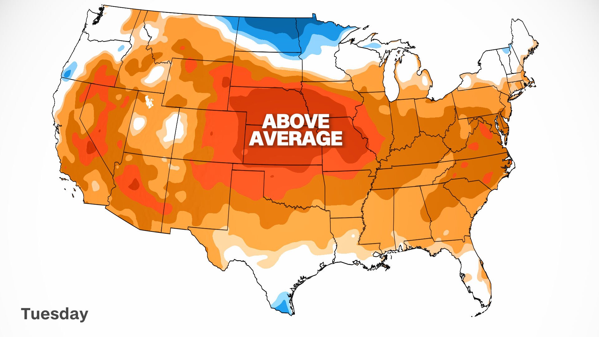
CNN Weather
The first day of meteorological spring on Tuesday will feel above average for many across the nation.
There is no doubt this winter has been brutal for some. Across the northern tier of the country, an already cold region, temperatures were well below seasonal norms.
John Gottschalck is chief of the operational prediction branch at NOAA’s Climate Prediction Center (CPC). He’s one of the experts coming up with the long-range forecast, and to come up with a forecast, you need to look at the past.
He noted one of the things standing out to him from the winter was the relentless rain falling across the mid-Mississippi River Valley, resulting in flooding.
In the West, lots of rain fell early in the season, but shut off when California was supposed to get its peak rainfall, causing the region to end the season well below normal.
Gottschalck acknowledged how wet or dry a region is currently could have an impact on the next three months.
He explained the soil moisture of a region can play into the temperatures longer-term, meaning if an area is very wet, its temperatures could end up a little cooler. By contrast, if an area is exceptionally dry, its temperatures could end up slightly above normal.
“Lots of surface water, whether it be from any flooding, or just higher rivers, or just soil moisture above normal can tend to keep the temperatures below normal or lower than they would normally be,” Gottschalck outlined. “Certain areas that have been quite dry, for example, are going to get a little bit of a bump up, potentially, for above normal temperatures.”
A case in point: California. We were all optimistic early in the season with all the rainfall received there in December, and then, nothing, proving how quickly things can change for the better or the worse.
“We had all that excitement about drought improvement and there was definitely a lot in the West, early on in December,” Gottschalck recounted. “But right now, if you look at the 90-day departures for normal, Northern California and Oregon are considerably below normal the last two months, so that actually trumped.”
Moving forward, California could pick up where it left off, with a continuation of a drier and warmer pattern, as could Texas.
“Texas had one of its hottest Decembers ever,” Gottschalck reported. “Those conditions will play some role in the outlook moving forward, because that feedback can produce warmer temperatures.”
One thing to note is the continuation of the La Niña pattern, a phenomenon where cooler-than-normal sea surface temperatures occur in the Pacific near the equator. It impacts weather all over the globe, including an increase in Atlantic hurricanes.
Learn more about La Niña
La Niña influenced this winter, including the early season rain events in the West, colder-than-normal temperatures across the north, and warmer-than-normal conditions in the south.
“The La Niña pattern often produces cold in the Pacific Northwest and along the West Coast, and even into the northern Plains, and that can linger well into March,” Gottschalck pointed out. “If that lingers further into March, it may be a colder start more like La Niña in the early part of the spring.”
Gottschalck added we will start to move away from a La Niña pattern later in the spring.
“As you enter into more neutral conditions, you lose some of your climate reliability, forecasting-wise,” Gottschalck explained.
“We start to focus a little bit on where we have deficits and or surpluses in snow cover and snow water equivalent and soil moisture in the springtime, because those can feed back to the atmospheric temperature,” Gottschalck emphasized.
Places like the Ohio Valley and Tennessee Valley will likely stay on the cooler side, partly because of all the rain they have received.
And as we know, these outlooks are for the season as a whole. There will be ups and downs, wet periods and dry ones all within the season.
But spring is right around the corner, no matter when you consider spring to “officially” begin.
Back on Groundhog Day, famous rodent Punxsutawney Phil predicted six more weeks of winter. Here’s a bunch of pictures of groundhogs and their handlers:
-
22 photos of groundhogs and guys in top hats to celebrate Groundhog Day 2022
KEITH SRAKOCIC
Punxsutawney Phil, the weather predicting groundhog, is held by his handler Bill Deeley on his den after the prediction of six more weeks of winter in Punxsutawney, Pa. on Thursday, Feb. 2, 2006. (AP Photo/Keith Srakocic)
KEITH SRAKOCIC
Punxsutawney Phil, the weather predicting groundhog, is held by his handler Bill Deeley on his den after the prediction of six more weeks of winter in Punxsutawney, Pa. on Thursday, Feb. 2, 2006. (AP Photo/Keith Srakocic)
-
22 photos of groundhogs and guys in top hats to celebrate Groundhog Day 2022
Lucas
Jim Means holds up a sleepy Punxsutawney Phil at daybreak, Feb. 2, 1980, in Punxsutawney, Penn., in front of a crowd of anxious people. The groundhog saw his shadow and proclaimed six more weeks of winter. Means cares for Phil throughout the year in the animal's home in the town library. (AP Photo)
-
-
22 photos of groundhogs and guys in top hats to celebrate Groundhog Day 2022
KEITH SRAKOCIC
A sculpture of a groundhog made out of pieces of mirrors is in display in the park in downtown Punxsutawney along with similar groundhog pieces on Wednesday, Feb. 1 ,2006. the day before the annual festivity with the weather prognosticating Punxsutawney Phil. (AP Photo/Keith Srakocic)
-
22 photos of groundhogs and guys in top hats to celebrate Groundhog Day 2022
Carolyn Kaster
John Griffiths, a handler of the weather-predicting groundhog Punxsutawney Phil, holds Phil in the air after removing him from his stump at Gobbler's Knob on Groundhog Day, Monday, Feb. 2, 2009, in Punxsutawney, Pa. The Groundhog Club said Phil saw his shadow and predicted six more weeks of winter. (AP Photo/Carolyn Kaster)
-
-
22 photos of groundhogs and guys in top hats to celebrate Groundhog Day 2022
Gene J. Puskar
Punxsutawney Phil, right, is held by Ben Hughes after emerging from his burrow on Gobblers Knob in Punxsutawney, Pa., to see his shadow and forecast six more weeks of winter weather Tuesday, Feb. 2, 2010. (AP Photo/Gene J. Puskar)
Gene J. Puskar
Punxsutawney Phil, right, is held by Ben Hughes after emerging from his burrow on Gobblers Knob in Punxsutawney, Pa., to see his shadow and forecast six more weeks of winter weather Tuesday, Feb. 2, 2010. (AP Photo/Gene J. Puskar)
-
22 photos of groundhogs and guys in top hats to celebrate Groundhog Day 2022
KEITH SRAKOCIC
Handler Bill Deeley holds Punxsutawney Phil, left, as Punxsutawney Groundhog club President William Cooper reads the proclamation that there would be six more weeks of winter after Phil saw his shadow in Puxsutawney, Pa. on Wednesday, Feb. 2, 2005 (AP Photo/Keith Srakocic)
KEITH SRAKOCIC
Handler Bill Deeley holds Punxsutawney Phil, left, as Punxsutawney Groundhog club President William Cooper reads the proclamation that there would be six more weeks of winter after Phil saw his shadow in Puxsutawney, Pa. on Wednesday, Feb. 2, 2005 (AP Photo/Keith Srakocic)
-
-
22 photos of groundhogs and guys in top hats to celebrate Groundhog Day 2022
Carolyn Kaster
Punxsutawney Phil, the weather predicting groundhog, is held up by his handlers Ben Hughes, left, and John Griffith to one of the largest crowds ever who came to hear the prediction of an early spring in Punxsutawney, Pa., Friday, Feb. 2, 2007. Phil did not see his shadow on Friday which, according to German folklore, means folks can expect an early spring instead of six more weeks of winter. (AP Photo/Carolyn Kaster)
-
22 photos of groundhogs and guys in top hats to celebrate Groundhog Day 2022
ASSOCIATED PRESS
Sam Light, center, president of the Punxsutawney Groundhog Club, points to a sign held by members of the club in Gobbler's Knob, Punxsutawney, Pennsylvania, Jan. 1961. They posed for the picture a few days before Groundhog Day, Feb. 2, with a stuffed stand-in for Punxsutawney Phil. (AP Photo)
-
-
22 photos of groundhogs and guys in top hats to celebrate Groundhog Day 2022
TODD PLITT
"Staten Island Chuck", described as the tri-state area's official spring weather forecaster, center, greets waiting onlookers at the Staten Island Zoo, in the Staten Island borough of New York Sunday, Feb. 2, 1997. Zoo Director Vincent Gattullo said that Chuck "saw no shadow upon exiting the front door of his miniature cottage... All New Yorkers may assume that spring will be here before they know it!"(AP Photo/Adam Nadel)
-
22 photos of groundhogs and guys in top hats to celebrate Groundhog Day 2022
Keith Srakocic
Punxsutawney Phil, the weather predicting groundhog, stands on the shoulder of one of his handlers John Griffiths after the Groundhog Club claimed that Phil did not see his shadow and winter has ended on Groundhog Day, Wednesday, Feb. 2, 2011, in Punxsutawney, Pa. (AP Photo/Keith Srakocic)
-
-
22 photos of groundhogs and guys in top hats to celebrate Groundhog Day 2022
Keith Srakocic
Groundhog Club President Bill Deeley, right, looks and listens to Punxsutawney Phil, the weather predicting groundhog, as handler John Griffiths, left, awaits the prediction that winter has ended on Groundhog Day, Wednesday, Feb. 2, 2011, in Punxsutawney, Pa. (AP Photo/Keith Srakocic)
-
22 photos of groundhogs and guys in top hats to celebrate Groundhog Day 2022
Gene J. Puskar
Groundhog Club handler John Griffiths holds Punxsutawney Phil, the weather prognosticating groundhog, during the 126th celebration of Groundhog Day on Gobbler's Knob in Punxsutawney, Pa. Thursday, Feb. 2, 2012. Phil saw his shadow, forecasting six more weeks of winter weather. (AP Photo/Gene J. Puskar)
-
-
22 photos of groundhogs and guys in top hats to celebrate Groundhog Day 2022
Barry Reeger
Groundhog Club co-handler Al Dereume holds Punxsutawney Phil, the weather prognosticating groundhog, during the 134th celebration of Groundhog Day on Gobbler's Knob in Punxsutawney, Pa. Sunday, Feb. 2, 2020. Phil's handlers said that the groundhog has forecast an early spring. (AP Photo/Barry Reeger)
-
22 photos of groundhogs and guys in top hats to celebrate Groundhog Day 2022
Gene J. Puskar
Groundhog Club handler Ron Ploucha holds Punxsutawney Phil, the weather prognosticating groundhog, during the 126th celebration of Groundhog Day on Gobbler's Knob in Punxsutawney, Pa. Thursday, Feb. 2, 2012. Phil saw his shadow, forecasting six more weeks of winter weather. (AP Photo/Gene J. Puskar)
-
-
22 photos of groundhogs and guys in top hats to celebrate Groundhog Day 2022
Gene J. Puskar
Groundhog Club handler Ron Ploucha, center, holds Punxsutawney Phil, the weather prognosticating groundhog, during the 129th celebration of Groundhog Day on Gobbler's Knob in Punxsutawney, Pa., Monday, Feb. 2, 2015. Phil's handlers said that the groundhog has forecast six more weeks of winter weather. (AP Photo/Gene J. Puskar)
-
22 photos of groundhogs and guys in top hats to celebrate Groundhog Day 2022
Gene J. Puskar
Punxsutawney Phil, the weather prognosticating groundhog, sits on display after making his prediction of six-more weeks of winter during the 129th celebration of Groundhog Day on Gobbler's Knob in Punxsutawney, Pa. Monday, Feb. 2, 2015. (AP Photo/Gene J. Puskar)
Gene J. Puskar
Punxsutawney Phil, the weather prognosticating groundhog, sits on display after making his prediction of six-more weeks of winter during the 129th celebration of Groundhog Day on Gobbler's Knob in Punxsutawney, Pa. Monday, Feb. 2, 2015. (AP Photo/Gene J. Puskar)
-
-
22 photos of groundhogs and guys in top hats to celebrate Groundhog Day 2022
Gene Herrick
Milwaukee Groundhog Club members try to coax Junior, year-old groundhog, out of his Washington Park cave, Feb. 2, 1952. Cloudy weather ruled out the possibility of Junior seeing his shadow and returning to the cave for six more weeks of winter hibernation. Club members, from left are: Tait Clifford, George Speidel, Harold Phelan, U.S. meteorologist Howard J. Thompson and Susan Phelan, 7. (AP Photo/Gene Herrick)
-
22 photos of groundhogs and guys in top hats to celebrate Groundhog Day 2022
Keith Srakocic
FILE - In this file photo from Feb. 2, 2011, Punxsutawney Phil, the weather predicting groundhog, is seen on his stump during the annual Groundhog Day festivities in Punxsutawney, Pa. The Groundhog Club claimed that Phil did not see his shadow last year and predicted that winter had ended. This year, the unseasonably warm temperatures and a marked lack of snow this year would seem to put less pressure on Phil. The central Pennsylvania groundhog is set to make his annual weather prediction on Thursday just before 7:30 a.m. (AP Photo/Keith Srakocic/FILE)
-
-
22 photos of groundhogs and guys in top hats to celebrate Groundhog Day 2022
Gene J. Puskar
Groundhog Club co-handler Al Dereume, right, holds Punxsutawney Phil, the weather prognosticating groundhog, during the 133rd celebration of Groundhog Day on Gobbler's Knob in Punxsutawney, Pa. Saturday, Feb. 2, 2019. Phil's handlers said that the groundhog has forecast an early spring. (AP Photo/Gene J. Puskar)
-
22 photos of groundhogs and guys in top hats to celebrate Groundhog Day 2022
Barry Reeger
Groundhog Club co-handler Al Dereume holds Punxsutawney Phil, the weather prognosticating groundhog, during the 134th celebration of Groundhog Day on Gobbler's Knob in Punxsutawney, Pa. Sunday, Feb. 2, 2020. Phil's handlers said that the groundhog has forecast an early spring. (AP Photo/Barry Reeger)
-
-
22 photos of groundhogs and guys in top hats to celebrate Groundhog Day 2022
RAY STUBBLEBINE
In this photo provided by Vaseline, Groundhog Punxsutawney Phil gets a reaction from Vaseline employees Laurel Johnson, left, and Margaret Baker, center, as he emerges from a box after handler Bill Deeley, right, placed him there while visiting Vaseline's exhibit tent in Barclay Square in the center of Punxsutawney, PA, Wednesday, Feb. 1, 2006. When throngs of people descend upon Punxsutawney to celebrate Groundhog Day on Thursday, businesses and other groups will try to ride the coattails of the cute and cuddly Punxsutawney Phil to gain publicity. (AP Photo/Vaseline, Ray Stubblebine)
-
22 photos of groundhogs and guys in top hats to celebrate Groundhog Day 2022
Barry Reeger
Groundhog Club handler A.J. Dereume holds Punxsutawney Phil, the weather prognosticating groundhog, as Vice President Tom Dunkel reads the scroll during the 135th celebration of Groundhog Day on Gobbler's Knob in Punxsutawney, Pa. Tuesday, Feb. 2, 2021. Phil's handlers said that the groundhog has forecast six more weeks of winter weather during this year's event that was held without anyone in attendance due to potential COVID-19 risks. (AP Photo/Barry Reeger)
