
August poised to not have a named Atlantic storm for the 1st time in 25 years
It isn’t your imagination. The tropics in the Atlantic Ocean have been very quiet this year despite a forecast from NOAA and other experts forecasting an above-average season.
There hasn’t been a named storm since the beginning of July, and if one doesn’t form by the end of the day, it will be the first August in 25 years not to have a named storm.
“Since 1950, two Augusts have had no Atlantic named storm formations: 1961 and 1997,” tweeted Phil Klotzbach, a research scientist at Colorado State University.
And it’s not just August. Klotzbach also tweeted:
“For the first time since 1941, the Atlantic has had no named storm (e.g., tropical storm or #hurricane) activity from July 3rd-August 30th.”
But the trend may not continue.
“This remarkably quiet Atlantic tropical cyclone period is likely to end soon,” Klotzbach said Wednesday morning.
Hurricane season is about to ramp up
The National Hurricane Center is actively watching three areas for tropical cyclone formation over the next five days. Two have a high chance of forming, and one off the west coast of Africa has a medium chance of developing.
The computer forecast models show a possible hurricane spinning toward the U.S. by the Labor Day holiday weekend. But the models then show the storm doing a U-turn and moving back into the Atlantic, possibly coming close to Bermuda.
Conditions look fairly good to have three hurricanes in the next 10 days, Klotzbach told CNN, added that having five more hurricanes after Sept. 10 would not be difficult.
Still, the hurricane seasonal above-average predictions might fall short this year.
“Colorado State University’s final seasonal hurricane forecast was issued in early August, but the odds of these forecasts verifying correctly are going down by the day,” Klotzbach acknowledged.
“Now, the odds of getting 20 named storms, 10 hurricanes and 5 majors are really low,” Klotzbach said.
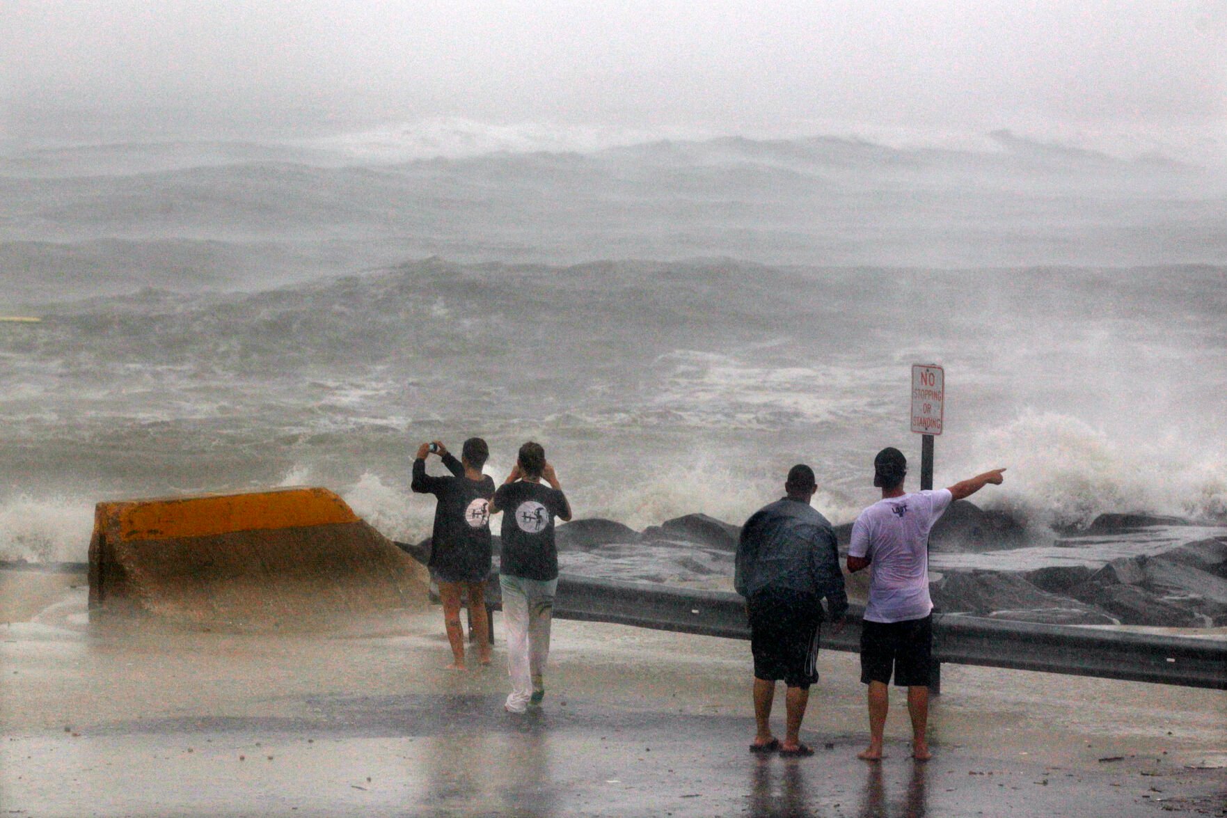
AP Photo/Mel Evans
In this Aug. 27, 2011, file photo, people stand at the end of a street in Cape May, N.J., looking at a stormy Atlantic Ocean as Hurricane Irene arrives.
Looking back historically, the other two years with no named storms in August had quite different outcomes.
“1961 ended up a hyperactive hurricane season with an extremely busy September-November, while 1997 was a below-average season,” Klotzbach tweeted.
There have been a few factors that likely led to a quiet July and August in the Atlantic basin, CNN meteorologist Taylor Ward said. “Primarily above-normal wind shear and dry air.”
Wind shear is the change of wind speed and strength with height in the atmosphere. High levels of wind shear prevent tropical disturbances from developing into well-organized systems and can also tear apart systems that do begin to form.
“We are currently in a La Niña pattern which typically leads to reduced wind shear over the Caribbean and tropical Atlantic,” he noted. “So the fact that we have, so far, seen above normal wind shear is surprising.”
-
Climate-driven floods heighten US well water contamination risksTed Powers
A gigantic clean-up task is underway along the Texas Gulf Coast where hurricane Allen left his mark after stomping ashore on Sunday morning. Here workmen clear debris from around overturned pleasure boats at the Corpus Christi marina, Texas on August 12, 1980. (AP Photo/Ted Powers)
Ted PowersA gigantic clean-up task is underway along the Texas Gulf Coast where hurricane Allen left his mark after stomping ashore on Sunday morning. Here workmen clear debris from around overturned pleasure boats at the Corpus Christi marina, Texas on August 12, 1980. (AP Photo/Ted Powers)
-
Climate-driven floods heighten US well water contamination risksRon Heflin
Employees of the Spin-N-Mart food store in Baytown take inventory and clean up what was left over after Hurricane Alicia stripped off the roof, Aug. 20, 1983. (AP Photo/Ron Heflin)
Ron HeflinEmployees of the Spin-N-Mart food store in Baytown take inventory and clean up what was left over after Hurricane Alicia stripped off the roof, Aug. 20, 1983. (AP Photo/Ron Heflin)
-
-
Climate-driven floods heighten US well water contamination risksTannen Maury
Two Gulfport, Miss., men look at cars damaged when a tornado tore the roof off a school on Monday, Sept. 2, 1985 in Gulfport, Mississippi. The tornado followed in the wake of Hurricane Elena whose eye came ashore over Biloxi/Gulfport. (AP Photo/Tannen Maury)
Tannen MauryTwo Gulfport, Miss., men look at cars damaged when a tornado tore the roof off a school on Monday, Sept. 2, 1985 in Gulfport, Mississippi. The tornado followed in the wake of Hurricane Elena whose eye came ashore over Biloxi/Gulfport. (AP Photo/Tannen Maury)
-
Climate-driven floods heighten US well water contamination risksJ. Scott Applewhite
FILE- In this Sept. 23, 1989 file photo, Lou de Liesseline pauses in despair after looking at the damage to her home on Folly Beach. The water surge caused by Hurricane Hugo moved the house off its foundations and back 100 feet. Hurricane Hugo might have been the first modern U.S. storm ushering in an era of live TV coverage and large scale coastal evacuations. (AP Photo/J. Scott Applewhite, File)
J. Scott ApplewhiteFILE- In this Sept. 23, 1989 file photo, Lou de Liesseline pauses in despair after looking at the damage to her home on Folly Beach. The water surge caused by Hurricane Hugo moved the house off its foundations and back 100 feet. Hurricane Hugo might have been the first modern U.S. storm ushering in an era of live TV coverage and large scale coastal evacuations. (AP Photo/J. Scott Applewhite, File)
-
-
Climate-driven floods heighten US well water contamination risksStephen Rose
New England regional FEMA chief Ed Thomas, right, talks with Frank and Mary Mahady, Sept. 25, 1991 of Mattapoisett, Mass., whose home, seen intact in far background, survived Hurricane Bob because it was built to be hurricane-resistant. Federal officials are trying to convince people rebuilding structures to follow hurricane-resistant construction plans. (AP Photo/Stephen Rose)
Stephen RoseNew England regional FEMA chief Ed Thomas, right, talks with Frank and Mary Mahady, Sept. 25, 1991 of Mattapoisett, Mass., whose home, seen intact in far background, survived Hurricane Bob because it was built to be hurricane-resistant. Federal officials are trying to convince people rebuilding structures to follow hurricane-resistant construction plans. (AP Photo/Stephen Rose)
-
Climate-driven floods heighten US well water contamination risksReed Saxon
A Poipu Beach resort on the Hawaiian island of Kauai is heavily damaged following high winds and rain from Hurricane Iniki, Sept. 12, 1992. The island remains without electricity and the airports are closed. (AP Photo/Reed Saxon)
Reed SaxonA Poipu Beach resort on the Hawaiian island of Kauai is heavily damaged following high winds and rain from Hurricane Iniki, Sept. 12, 1992. The island remains without electricity and the airports are closed. (AP Photo/Reed Saxon)
-
-
Climate-driven floods heighten US well water contamination risksMARK FOLEY
Hurricane Opal's devastation to housing along Panama City Beach, Fla., is shown in an Oct. 5, 1995 file photo. Insurers are watching a new hurricane season blow into Florida hoping to "dodge bullets" again. (AP Photo/Mark Foley, File)
MARK FOLEYHurricane Opal's devastation to housing along Panama City Beach, Fla., is shown in an Oct. 5, 1995 file photo. Insurers are watching a new hurricane season blow into Florida hoping to "dodge bullets" again. (AP Photo/Mark Foley, File)
-
Climate-driven floods heighten US well water contamination risksBRUCE GRANER
Emergency medical crews on ATV patrol keep a sharp eye out for residents who may need medical aide Sunday, Oct. 8, 1995, during the second day residents were allowed back on Pensacola Beach to check on personal property damaged by Hurricane Erin. This view is of Ariola Drive on the gulf-side of Pensacola Beach which was one of the hardest hit areas in Pensacola. (AP Photo/Pensacola News Journal,Bruce Graner)
BRUCE GRANEREmergency medical crews on ATV patrol keep a sharp eye out for residents who may need medical aide Sunday, Oct. 8, 1995, during the second day residents were allowed back on Pensacola Beach to check on personal property damaged by Hurricane Erin. This view is of Ariola Drive on the gulf-side of Pensacola Beach which was one of the hardest hit areas in Pensacola. (AP Photo/Pensacola News Journal,Bruce Graner)
-
-
Climate-driven floods heighten US well water contamination risksKARL DEBLAKER
A house sits in the surf, Tuesday, Oct. 8, 1996, left in ruins after Hurricane Fran struck the tiny beach town of North Topsail in early September. Nearly every house received major damage from the storm. Preparation for a storm season is incumbent on consumers to strengthen existing properties now or construct new homes or major remodel projects as best they can to fend off storm damage this year and in succeeding years. (AP Photo/Karl DeBlaker)
KARL DEBLAKERA house sits in the surf, Tuesday, Oct. 8, 1996, left in ruins after Hurricane Fran struck the tiny beach town of North Topsail in early September. Nearly every house received major damage from the storm. Preparation for a storm season is incumbent on consumers to strengthen existing properties now or construct new homes or major remodel projects as best they can to fend off storm damage this year and in succeeding years. (AP Photo/Karl DeBlaker)
-
Climate-driven floods heighten US well water contamination risksBRETT COOMER
Shawn Anderson, left, and Victoria Dues hold onto a street sign after their car stalled out while driving through floodwaters caused by Tropical Storm Frances Friday, Sept. 11, 1998, in Houston. The storm hit land early Friday and storms dumped heavy rain on the Houston area, flooding streets and homes throughout the city and outlying areas. (AP Photo/Brett Coomer)
BRETT COOMERShawn Anderson, left, and Victoria Dues hold onto a street sign after their car stalled out while driving through floodwaters caused by Tropical Storm Frances Friday, Sept. 11, 1998, in Houston. The storm hit land early Friday and storms dumped heavy rain on the Houston area, flooding streets and homes throughout the city and outlying areas. (AP Photo/Brett Coomer)
-
-
Climate-driven floods heighten US well water contamination risksDave Martin
FILE - In this Sept. 25, 1998 file photo, taken by Dave Martin, Key West residents Brian Goss, left, George Wallace and Michael Mooney, right, hold on to each other as they battle 90 mph winds along Houseboat Row in Key West, Fla., after the three had sought shelter behind a Key West hotel as Hurricane Georges descended on the Florida Keys. They were forced to seek other shelter when the storm conditions became too rough. Martin, a longtime Associated Press photographer based in Montgomery, Ala., died after collapsing on the Georgia Dome field at the Chick-fil-A Bowl footballg ame on Tuesday, Dec. 31, 2013. Martin was 59. (AP Photo/Dave Martin, File)
Dave MartinFILE - In this Sept. 25, 1998 file photo, taken by Dave Martin, Key West residents Brian Goss, left, George Wallace and Michael Mooney, right, hold on to each other as they battle 90 mph winds along Houseboat Row in Key West, Fla., after the three had sought shelter behind a Key West hotel as Hurricane Georges descended on the Florida Keys. They were forced to seek other shelter when the storm conditions became too rough. Martin, a longtime Associated Press photographer based in Montgomery, Ala., died after collapsing on the Georgia Dome field at the Chick-fil-A Bowl footballg ame on Tuesday, Dec. 31, 2013. Martin was 59. (AP Photo/Dave Martin, File)
-
Climate-driven floods heighten US well water contamination risksSTEPHAN SAVOIA
Residents of Portsmouth, Va., form a line to receive drinking water being distributed by the Virgina National Guard in a shopping mall parking lot Friday, Sept. 17, 1999. Distribution was to begin at noon with residents arriving as early as 9:00 a.m. to wait in line. Water still had not arrived by late afternoon. More than 100,000 people living in Portsmouth and parts of Chesapeake and Suffolk Virginia are without water in the aftermath of Hurricane Floyd. Officials say it may be as long as seven to 10days before the water system is back on line. (AP Photo/Stephan Savoia)
STEPHAN SAVOIAResidents of Portsmouth, Va., form a line to receive drinking water being distributed by the Virgina National Guard in a shopping mall parking lot Friday, Sept. 17, 1999. Distribution was to begin at noon with residents arriving as early as 9:00 a.m. to wait in line. Water still had not arrived by late afternoon. More than 100,000 people living in Portsmouth and parts of Chesapeake and Suffolk Virginia are without water in the aftermath of Hurricane Floyd. Officials say it may be as long as seven to 10days before the water system is back on line. (AP Photo/Stephan Savoia)
-
-
Climate-driven floods heighten US well water contamination risksMICHAEL STRAVATO
After losing electricity and backup generators due to flooding from Tropical Storm Allison, doctors and nurses at Herman Hospital evacuate a critically ill patient down powerless escalator stairs in Houston, in a Saturday, June 9, 2001 file photo. Officials of Houston hospitals say that as a result of the 2001 disaster, their institutions are in better shape to face Hurricane Rita. (AP Photo/Michael Stravato, File)
MICHAEL STRAVATOAfter losing electricity and backup generators due to flooding from Tropical Storm Allison, doctors and nurses at Herman Hospital evacuate a critically ill patient down powerless escalator stairs in Houston, in a Saturday, June 9, 2001 file photo. Officials of Houston hospitals say that as a result of the 2001 disaster, their institutions are in better shape to face Hurricane Rita. (AP Photo/Michael Stravato, File)
-
Climate-driven floods heighten US well water contamination risksMARK LENNIHAN
The devastation left by Hurricane Andrew is clear in this Sept. 4, 1992 aerial file photo over Florida City, Fla. The storm damage to Florida City, Homestead and other small cities south of Miami was estimated at $30 billion, leaving some 180,000 people homeless. (AP Photo/Mark Lennihan, File)
MARK LENNIHANThe devastation left by Hurricane Andrew is clear in this Sept. 4, 1992 aerial file photo over Florida City, Fla. The storm damage to Florida City, Homestead and other small cities south of Miami was estimated at $30 billion, leaving some 180,000 people homeless. (AP Photo/Mark Lennihan, File)
-
-
Climate-driven floods heighten US well water contamination risksDAVE MARTIN
In this Oct. 3, 2002 file photo, Eusie Leboeuf of Pointe Aux Chenes, La., plays in the water in front of the Knights of Columbus Hall. A levee in this small south Louisiana town broke as Hurricane Lili came ashore, causing hundreds of homes to be flooded. It is the second time in ten years that Pointe Aux Chenes has flooded because of hurricanes. (AP Photo/Dave Martin, file)
DAVE MARTINIn this Oct. 3, 2002 file photo, Eusie Leboeuf of Pointe Aux Chenes, La., plays in the water in front of the Knights of Columbus Hall. A levee in this small south Louisiana town broke as Hurricane Lili came ashore, causing hundreds of homes to be flooded. It is the second time in ten years that Pointe Aux Chenes has flooded because of hurricanes. (AP Photo/Dave Martin, file)
-
Climate-driven floods heighten US well water contamination risksSUSAN WALSH
Dozens of people gather in flooded downtown Annapolis, Md., Sept. 19, 2003, to see the water damage from Hurricane Isabel. Rising tides fed by high winds and rains from Isabel pushed water inland to low-lying areas around the Chesapeake Bay and Potomac River flooding homes and businesses. Shortly after Hurricane Katrina swept across the south, Cambridge Mayor Cleveland Rippons met with Dorchester County emergency officials and hosted a town hall meeting, in partto reassure residents about the city's disaster response plan. (AP Photo/Susan Walsh)
SUSAN WALSHDozens of people gather in flooded downtown Annapolis, Md., Sept. 19, 2003, to see the water damage from Hurricane Isabel. Rising tides fed by high winds and rains from Isabel pushed water inland to low-lying areas around the Chesapeake Bay and Potomac River flooding homes and businesses. Shortly after Hurricane Katrina swept across the south, Cambridge Mayor Cleveland Rippons met with Dorchester County emergency officials and hosted a town hall meeting, in partto reassure residents about the city's disaster response plan. (AP Photo/Susan Walsh)
-
-
Climate-driven floods heighten US well water contamination risksCHRIS O'MEARA
A Port Charlotte hardware store worker tries to salvage items from the store Saturday afternoon Aug. 14, 2004, in Port Charlotte, Fla. Hurricane Charley plowed through the area Friday afternoon leaving behind a path of destruction. (AP Photo/Chris O'Meara)
CHRIS O'MEARAA Port Charlotte hardware store worker tries to salvage items from the store Saturday afternoon Aug. 14, 2004, in Port Charlotte, Fla. Hurricane Charley plowed through the area Friday afternoon leaving behind a path of destruction. (AP Photo/Chris O'Meara)
-
Climate-driven floods heighten US well water contamination risksCHUCK BURTON
Workers try to clear a mud slide on Interstate 40 outside of Black Mountain, N.C., Thursday, Sept. 9, 2004 after the remnants of Hurricane Frances brought heavy rains and flooding to the area. (AP Photo/Chuck Burton)
CHUCK BURTONWorkers try to clear a mud slide on Interstate 40 outside of Black Mountain, N.C., Thursday, Sept. 9, 2004 after the remnants of Hurricane Frances brought heavy rains and flooding to the area. (AP Photo/Chuck Burton)
-
-
Climate-driven floods heighten US well water contamination risksDALE SPARKS
McKinleyville, W.Va. resident Bob Ohler walks through the debris left behind in Buffalo Creek, Tuesday, Sept. 21, 2004, in McKinleyville, after flooding from remnants of Hurricane Ivan last Friday devasted the rural Brooke County town. (AP Photo/Dale Sparks)
DALE SPARKSMcKinleyville, W.Va. resident Bob Ohler walks through the debris left behind in Buffalo Creek, Tuesday, Sept. 21, 2004, in McKinleyville, after flooding from remnants of Hurricane Ivan last Friday devasted the rural Brooke County town. (AP Photo/Dale Sparks)
-
Climate-driven floods heighten US well water contamination risksDAVE MARTIN
Faith Glionna sits outside her nail salon as she waits for power to be retored in Indialantic, Fla., on Tuesday, Sept. 28, 2004. Glionna lost her home to Hurricane Frances three weeks ago and moved in with her mother, whose roof was blown off when Hurricane Jeanne struck the Florida coast last weekend. (AP Photo/Dave Martin)
DAVE MARTINFaith Glionna sits outside her nail salon as she waits for power to be retored in Indialantic, Fla., on Tuesday, Sept. 28, 2004. Glionna lost her home to Hurricane Frances three weeks ago and moved in with her mother, whose roof was blown off when Hurricane Jeanne struck the Florida coast last weekend. (AP Photo/Dave Martin)
-
-
Climate-driven floods heighten US well water contamination risksJOHN BAZEMORE
Residents of Navarre Beach, Fla., walk past damage from Hurricane Dennis Monday, July 11, 2005. (AP Photo/John Bazemore)
JOHN BAZEMOREResidents of Navarre Beach, Fla., walk past damage from Hurricane Dennis Monday, July 11, 2005. (AP Photo/John Bazemore)
-
Climate-driven floods heighten US well water contamination risksDAVID J. PHILLIP
Homes destroyed by Hurricane Katrina are shown in this aerial view, Tuesday, Aug. 30, 2005, in New Orleans. (AP Photo/David J. Phillip)
DAVID J. PHILLIPHomes destroyed by Hurricane Katrina are shown in this aerial view, Tuesday, Aug. 30, 2005, in New Orleans. (AP Photo/David J. Phillip)
-
-
Climate-driven floods heighten US well water contamination risksERIC GAY
Emanuel Honeycutt is followed by his son Emanuel Jr., 11, as he carries his daughter Eman, 9, through floodwaters in the French Quarter in New Orleans, Tuesday, Aug. 30, 2005, after the area was hit by Hurricane Katrina. Officials called for a mandatory evacuation of the city, but many resident remained in the city. (AP Photo/Eric Gay)
ERIC GAYEmanuel Honeycutt is followed by his son Emanuel Jr., 11, as he carries his daughter Eman, 9, through floodwaters in the French Quarter in New Orleans, Tuesday, Aug. 30, 2005, after the area was hit by Hurricane Katrina. Officials called for a mandatory evacuation of the city, but many resident remained in the city. (AP Photo/Eric Gay)
-
Climate-driven floods heighten US well water contamination risksJUDI BOTTONI
Erroll Dominque walks through his ruined area of cane fields Nov. 7, 2005 in Erath, La. Hay rolls and other debris floated into his fields from the tidial surge caused by hurricane Rita. (AP Photo/Judi Bottoni)
JUDI BOTTONIErroll Dominque walks through his ruined area of cane fields Nov. 7, 2005 in Erath, La. Hay rolls and other debris floated into his fields from the tidial surge caused by hurricane Rita. (AP Photo/Judi Bottoni)
-
-
Climate-driven floods heighten US well water contamination risksJ. PAT CARTER
Mark Gordon sits on a mattress in his homemade shelter in a Plantation, Fla. Wednesday, Nov. 30, 2005, one month after Hurricane Wilma destroyed the home he was living in. The shelter is in the middle of hurricane-littered parking lot on the day hurricane season ends. He is doing odd jobs for FEMA crews cleaning up after the storm. (AP Photo/J. Pat Carter)
J. PAT CARTERMark Gordon sits on a mattress in his homemade shelter in a Plantation, Fla. Wednesday, Nov. 30, 2005, one month after Hurricane Wilma destroyed the home he was living in. The shelter is in the middle of hurricane-littered parking lot on the day hurricane season ends. He is doing odd jobs for FEMA crews cleaning up after the storm. (AP Photo/J. Pat Carter)
-
Climate-driven floods heighten US well water contamination risksDavid J. Phillip
Debris from Hurricane Ike lines the seawall Monday, Sept. 15, 2008 in Galveston, Texas. (AP Photo/David J. Phillip)
David J. PhillipDebris from Hurricane Ike lines the seawall Monday, Sept. 15, 2008 in Galveston, Texas. (AP Photo/David J. Phillip)
-
-
Climate-driven floods heighten US well water contamination risksBill Haber
Mary Kay Chetta looks through some of the lost items that evacuees lost during the evacuation from Hurricane Gustav at City Hall in New Orleans, Wednesday, Nov. 12, 2008. Roughly 3 percent of the 28,000 Gustav evacuees may have had their luggage lost or mishandled, according to state and city figures. (AP Photo/Bill Haber)
Bill HaberMary Kay Chetta looks through some of the lost items that evacuees lost during the evacuation from Hurricane Gustav at City Hall in New Orleans, Wednesday, Nov. 12, 2008. Roughly 3 percent of the 28,000 Gustav evacuees may have had their luggage lost or mishandled, according to state and city figures. (AP Photo/Bill Haber)
-
Climate-driven floods heighten US well water contamination risksSteve Helber
Visitors play in the wind as Hurricane Irene passes through Virginia Beach, Va., Saturday, Aug. 27, 2011. (AP Photo/Steve Helber)
Steve HelberVisitors play in the wind as Hurricane Irene passes through Virginia Beach, Va., Saturday, Aug. 27, 2011. (AP Photo/Steve Helber)
-
-
Climate-driven floods heighten US well water contamination risksGerald Herbert
Don Duplantier walks through his flooded home as water recedes from Hurricane Isaac in Braithwaite, La., Sunday, Sept. 2, 2012. In the foreground is a sign marking the waterline from Hurricane Katrina, but floodwater from Isaac went all the way up to the second floor. (AP Photo/Gerald Herbert)
Gerald HerbertDon Duplantier walks through his flooded home as water recedes from Hurricane Isaac in Braithwaite, La., Sunday, Sept. 2, 2012. In the foreground is a sign marking the waterline from Hurricane Katrina, but floodwater from Isaac went all the way up to the second floor. (AP Photo/Gerald Herbert)
-
Climate-driven floods heighten US well water contamination risksJohn Minchillo
FILE - In this Oct. 29, 2012 file photo, seawater floods the entrance to the Brooklyn Battery Tunnel during Superstorm Sandy in New York. Disaster experts say people have to think about the big disaster that happens only a few times a lifetime at most, but is devastating when it hits — Hurricane Katrina, Superstorm Sandy, the 2011 super outbreak of tornadoes, the 1906 San Francisco earthquake or a horrible pandemic. (AP Photo/ John Minchillo, File)
John MinchilloFILE - In this Oct. 29, 2012 file photo, seawater floods the entrance to the Brooklyn Battery Tunnel during Superstorm Sandy in New York. Disaster experts say people have to think about the big disaster that happens only a few times a lifetime at most, but is devastating when it hits — Hurricane Katrina, Superstorm Sandy, the 2011 super outbreak of tornadoes, the 1906 San Francisco earthquake or a horrible pandemic. (AP Photo/ John Minchillo, File)
-
-
Climate-driven floods heighten US well water contamination risksStephen B. Morton
A woman who identified herself as Valerie walks along flooded President Street after leaving her homeless camp after Hurricane Matthew caused flooding, Saturday, Oct. 8, 2016, in Savannah, Ga. Matthew plowed north along the Atlantic coast, flooding towns and gouging out roads in its path. (AP Photo/Stephen B. Morton)
Stephen B. MortonA woman who identified herself as Valerie walks along flooded President Street after leaving her homeless camp after Hurricane Matthew caused flooding, Saturday, Oct. 8, 2016, in Savannah, Ga. Matthew plowed north along the Atlantic coast, flooding towns and gouging out roads in its path. (AP Photo/Stephen B. Morton)
-
Climate-driven floods heighten US well water contamination risksLM Otero
FILE - In this Aug. 29, 2017 file photo, evacuees rest at the George R. Brown Convention Center that was been set up as a shelter operated by the Red Cross for evacuees escaping the floodwaters from Tropical Storm Harvey in Houston, Texas. The groups helping to rebuild on the Texas Gulf Coast after Hurricane Harvey have collected close to $1 billion in donations. Of the $853 million raised by major groups involved in the recovery, the most money has been collected by the Red Cross, which said this month that it's raised $493 million for Harvey relief. (AP Photo/LM Otero, File)
LM OteroFILE - In this Aug. 29, 2017 file photo, evacuees rest at the George R. Brown Convention Center that was been set up as a shelter operated by the Red Cross for evacuees escaping the floodwaters from Tropical Storm Harvey in Houston, Texas. The groups helping to rebuild on the Texas Gulf Coast after Hurricane Harvey have collected close to $1 billion in donations. Of the $853 million raised by major groups involved in the recovery, the most money has been collected by the Red Cross, which said this month that it's raised $493 million for Harvey relief. (AP Photo/LM Otero, File)
-
-
Climate-driven floods heighten US well water contamination risksCarlos Giusti
Manuel Morales Ortíz explains what his home suffered during the 2017 hurricane season, in Corozal, Puerto Rico, Monday, July 13, 2020. Nearly three years after Hurricane Maria tore through Puerto Rico, tens of thousands of homes remain badly damaged. (AP Photo/Carlos Giusti)
Carlos GiustiManuel Morales Ortíz explains what his home suffered during the 2017 hurricane season, in Corozal, Puerto Rico, Monday, July 13, 2020. Nearly three years after Hurricane Maria tore through Puerto Rico, tens of thousands of homes remain badly damaged. (AP Photo/Carlos Giusti)
-
Climate-driven floods heighten US well water contamination risksWilfredo Lee
Gustavo Mejia, left, of Miami, and his nephew Juan Sebastian Mejia, of Palmira, Colombia, take a selfie in front of a boarded up hotel on South Beach, Friday, Sept. 8, 2017, in Miami Beach, Fla. Juan Sebastian Mejia was on vacation from Colombia when his flight back home was cancelled. Hurricane Irma aimed its sights on millions of homes and businesses in Florida and officials warned that time was running out to evacuate ahead of the deadly hurricane, which was headed Friday on a long-feared path right through the heart of the peninsula. (AP Photo/Wilfredo Lee)
Wilfredo LeeGustavo Mejia, left, of Miami, and his nephew Juan Sebastian Mejia, of Palmira, Colombia, take a selfie in front of a boarded up hotel on South Beach, Friday, Sept. 8, 2017, in Miami Beach, Fla. Juan Sebastian Mejia was on vacation from Colombia when his flight back home was cancelled. Hurricane Irma aimed its sights on millions of homes and businesses in Florida and officials warned that time was running out to evacuate ahead of the deadly hurricane, which was headed Friday on a long-feared path right through the heart of the peninsula. (AP Photo/Wilfredo Lee)
-
-
Climate-driven floods heighten US well water contamination risksDavid Goldman
FILE- In this Wednesday, Sept. 19, 2018 file photo, part of the Starlite Motel is washed away in the aftermath of flooding from Hurricane Florence in Spring Lake, N.C. Florence washed away half the rooms at the Starlite Motel ripping away the livelihood of a family that bought it in recent months. (AP Photo/David Goldman, File.)
David GoldmanFILE- In this Wednesday, Sept. 19, 2018 file photo, part of the Starlite Motel is washed away in the aftermath of flooding from Hurricane Florence in Spring Lake, N.C. Florence washed away half the rooms at the Starlite Motel ripping away the livelihood of a family that bought it in recent months. (AP Photo/David Goldman, File.)
-
Climate-driven floods heighten US well water contamination risksGerald Herbert
FILE- In this Oct. 11, 2018 file photo, rescue personnel perform a search in the aftermath of Hurricane Michael in Mexico Beach, Fla. A year after Hurricane Michael, Bay County, Florida, is still in crisis. Thousands are homeless, medical care and housing are at a premium, and domestic violence is increasing. Michael was among the strongest hurricanes ever to make landfall in the United States. This summer, county officials unveiled a blueprint to rebuild. Among their ideas: Use shipping containers and 3-D technology to build new houses and offer signing bonuses to lure new doctors. (AP Photo/Gerald Herbert, File)
Gerald HerbertFILE- In this Oct. 11, 2018 file photo, rescue personnel perform a search in the aftermath of Hurricane Michael in Mexico Beach, Fla. A year after Hurricane Michael, Bay County, Florida, is still in crisis. Thousands are homeless, medical care and housing are at a premium, and domestic violence is increasing. Michael was among the strongest hurricanes ever to make landfall in the United States. This summer, county officials unveiled a blueprint to rebuild. Among their ideas: Use shipping containers and 3-D technology to build new houses and offer signing bonuses to lure new doctors. (AP Photo/Gerald Herbert, File)
-
-
Climate-driven floods heighten US well water contamination risksRamon Espinosa
Two Haitian migrants sit as one stands amid the ruins of a home destroyed by Hurricane Dorian in Abaco, Bahamas, Saturday, Sept. 28, 2019. A preliminary report estimates Dorian caused some $7 billion in damage, but the government has not yet offered any figures. (AP Photo/Ramon Espinosa)
Ramon EspinosaTwo Haitian migrants sit as one stands amid the ruins of a home destroyed by Hurricane Dorian in Abaco, Bahamas, Saturday, Sept. 28, 2019. A preliminary report estimates Dorian caused some $7 billion in damage, but the government has not yet offered any figures. (AP Photo/Ramon Espinosa)
-
Climate-driven floods heighten US well water contamination risksGerry Broome
High water signs are posted along Ocean Drive following the effects of Hurricane Isaias in Caswell Beach, N.C., Tuesday, Aug. 4, 2020. (AP Photo/Gerry Broome)
Gerry BroomeHigh water signs are posted along Ocean Drive following the effects of Hurricane Isaias in Caswell Beach, N.C., Tuesday, Aug. 4, 2020. (AP Photo/Gerry Broome)
-
-
Climate-driven floods heighten US well water contamination risksDavid J. Phillip
FILE - In this Thursday, Aug. 27, 2020 file photo, buildings and homes are flooded in the aftermath of Hurricane Laura in Cameron, La. Laura, which jumped 65 mph (105 kph) in the day before landfall, tied the record for the biggest rapid intensification in the Gulf of Mexico, said former hurricane hunter meteorologist Jeff Masters. (AP Photo/David J. Phillip)
David J. PhillipFILE - In this Thursday, Aug. 27, 2020 file photo, buildings and homes are flooded in the aftermath of Hurricane Laura in Cameron, La. Laura, which jumped 65 mph (105 kph) in the day before landfall, tied the record for the biggest rapid intensification in the Gulf of Mexico, said former hurricane hunter meteorologist Jeff Masters. (AP Photo/David J. Phillip)
-
Climate-driven floods heighten US well water contamination risksGerald Herbert
Sierra Patterson holds her three-week-old baby Tru Alexander in their flooded apartment where floodwaters reaches two feet inside, after Hurricane Sally moved through, Friday, Sept. 18, 2020, in , Fla. (AP Photo/Gerald Herbert)
Gerald HerbertSierra Patterson holds her three-week-old baby Tru Alexander in their flooded apartment where floodwaters reaches two feet inside, after Hurricane Sally moved through, Friday, Sept. 18, 2020, in , Fla. (AP Photo/Gerald Herbert)
-
-
Climate-driven floods heighten US well water contamination risksGerald Herbert
FILE - Soncia King holds onto her husband, Patrick King, in Lake Charles, La., Saturday, Oct. 10, 2020, as they walk through the flooded street to their home, after Hurricane Delta moved through the previous day. According to a study published in Nature Communications on Tuesday, April 12, 2022, climate change made the record-smashing deadly 2020 Atlantic hurricane season noticeably wetter. (AP Photo/Gerald Herbert, File)
Gerald HerbertFILE - Soncia King holds onto her husband, Patrick King, in Lake Charles, La., Saturday, Oct. 10, 2020, as they walk through the flooded street to their home, after Hurricane Delta moved through the previous day. According to a study published in Nature Communications on Tuesday, April 12, 2022, climate change made the record-smashing deadly 2020 Atlantic hurricane season noticeably wetter. (AP Photo/Gerald Herbert, File)
-
Climate-driven floods heighten US well water contamination risksGerald Herbert
Displaced caskets that floated away from a cemetery during flooding sits along a road in Ironton, La., Monday, Sept. 27, 2021. A month after Hurricane Ida, small communities along Louisiana's southeastern coast are still without power or running water. Some residents have lost most of their possessions to the storm's floodwaters. (AP Photo/Gerald Herbert)
Gerald HerbertDisplaced caskets that floated away from a cemetery during flooding sits along a road in Ironton, La., Monday, Sept. 27, 2021. A month after Hurricane Ida, small communities along Louisiana's southeastern coast are still without power or running water. Some residents have lost most of their possessions to the storm's floodwaters. (AP Photo/Gerald Herbert)
Categories: Trending